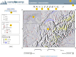
 CartoWeb siap digunakan dan komprehensif dan Web-GIS (Sistem Informasi Geografis) serta kerangka kerja yang nyaman untuk membangun aplikasi canggih dan disesuaikan. Dikembangkan oleh Camptocamp SA, itu didasarkan pada mesin UMN MapServer dan dirilis di bawah GNU General Public License (GPL).
Ditulis menggunakan bahasa PHP5 inovatif, CartoWeb adalah berkat sangat modular dan dapat dikustomisasi untuk arsitektur berorientasi objek. Ini berjalan merata pada Windows atau platform Unix-like dan menunjukkan kekuatan yang sesungguhnya bila terkait dengan PostgreSQL / PostGIS.
CartoWeb3 in Action
Several demos are available to demonstrate the range of functionalities that CartoWeb3 offers. Don't hesitate to try all those tools.-
Overall Demo
This demo gives an overview of CartoWeb common functionalities: browsing, querying, outlining, recentering, layers management, tabs browsing and PDF printing as well as its AJAX capability.
PDF map extent is defined using our new "WYSIWYG" DHTML tool.
The AJAX mode is activated in this demo: the map is updated without reloading the whole page, making the browsing even more fluid.
Users roles management is also demonstrated: as an example, you will have to be logged in (username: demo / password: demo) to be able to print PDF maps.
Click here to visit the overall demo.
-
Plugins Demo
This demo outlines the new functionalities introduced in recent CartoWeb versions. Among those new tools, let's list for instance:
- a routing module (shortest path calculation based on the Pgdijkstra routing module)
- a new geographic search interface based on AJAX
- a views system (bookmarks of given CartoWeb states)
- an improved multishape redlining/outlining system with label capabilities (associated to an advanced color/symbol picking system)
- a layers reordering system (useful to make some layers appear above some others)
- a tools icons dispatcher
- a collapsible keymap
- a WMS browsing interface making possible to include external layers in the map using WMS
- a DXF conversion tool for exporting drawn shapes to AutoCAD-like software
-
CS Demo
This demo demonstrates the high level of layout customization that is available with CartoWeb as well as some functionalities described in previous demos.
Geographic data are kindly provided by Cartosphere.
Please note that this demo is not included in CartoWeb distributions.
Click here to visit the CS demo.
-
Editing Demo
This demo demonstrates what CartoWeb can do in terms of distributed editing and persistent storage of geographical objects including:
- shapes: points, lines, polygons
- attributary data
Click here to visit the editing demo.
-
Geostatistics Demo
This demo gives an example of geostatistical data representation on a map (choropleth layers).
Click here to visit the geostat demo.
-
Basic Demo
This demo runs with absolutely no JavaScript and barely no CSS.
It has been designed to demonstrate the CartoWeb ability to be correctly used by basic user-agents such as PDAs, cellphones or simply web browsers with JavaScript turned off. Obviously not all advanced CartoWeb features are available with that mode.
Click here to visit the basic demo.
-
Development Demo
This is the default CartoWeb layout with features activated by default when you install CartoWeb. It is mainly used as a development project. Simple but comprehensive, it will be however a good start for many of your own projects.
Some functionalities are only available when logged in (use for instance username: x / password: x).
Click here to visit the development demo.
Source: http://www.cartoweb.org
0 komentar:
Post a Comment
Terima Kasih telah mengunjungi blog saya. Mohon kritikan dan sarannya ya :)